

[ad_1]
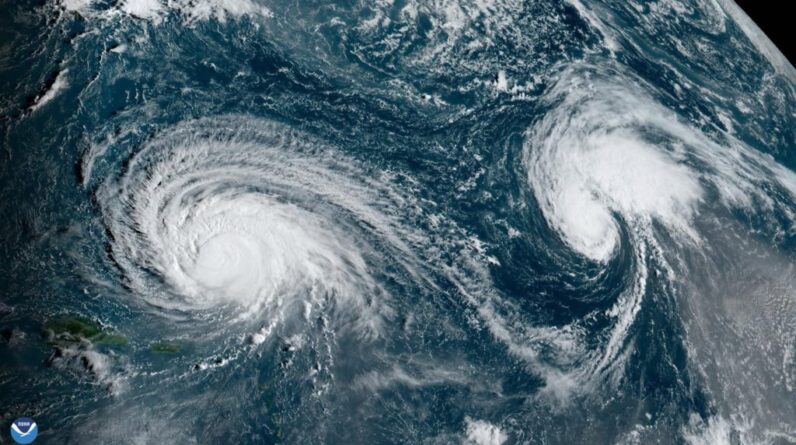
On the morning of Sept. 11, 2023, at 7:30 a.m. EDT, the Advanced Baseline Imager onboard NOAA’s GOES East satellite captured the above GeoColor image of Hurricane Lee churning over the Atlantic, northeast of Puerto Rico, as well as Tropical Storm Margot farther east, as the sun rose overhead.
Source – NOAA’s GOES East satellite
Hurricane Lee is slowing down as it prepares to make a long-anticipated turn that will likely bring it near Atlantic Canada or New England by this weekend.
At the 5:00 p.m. EDT advisory from the National Hurricane Center, Hurricane Lee was 600 miles (970 kilometers south of Bermuda, moving to the west-northwest at 7 mph (11 kph). Lee has maximum sustained winds of 115 mph (185 kph).
A slow west-northwest to northwest motion is expected during the next couple of days, followed by a turn toward the north by midweek. On the forecast track,
Lee is expected to pass near, but to the west, of Bermuda in a few days.
Lee is a Category 3 hurricane on the Saffir-Simpson Hurricane Wind Scale, and little change in strength is expected in the next few days. However, the storm’s eye has redeveloped, and is well-defined, while its structure is looking more symmetrical. This is an indication that Lee is determined to become at least a Category 4 storm.
Actually, that is in fact, what the NHC is forecasting now. Lee will most definitely gather fuel from the very warm waters that currently lie ahead. The ocean temperature Lee is passing over is a balmy 30 degrees Celsius or 86 degrees Fahrenheit.
By midweek, Lee will be rounding the southwest side of a large ridge of high pressure in the North Atlantic and will begin to feel the influence of an upper trough over eastern North America.

Forecast models are in agreement
Most forecast models are now in agreement that as Lee is influenced by the upper-level trough over eastern North America, plus the added energy derived from the warm Atlantic waters will cause a fairly sharp northward turn around Wednesday and a gradual northward acceleration through the rest of the week.
The final solutions of the two most prominent models, the GFS and European, both have consistently shown Lee not making a landfall in the U.S. but heading to the Canadian Maritimes instead.
According to Yale Climate Connections, there is sustained and increasing agreement among models that Lee will pass to the west of Bermuda (which NHC gave a 43 percent chance of experiencing tropical storm-force winds) and head toward Atlantic Canada – most likely Nova Scotia and New Brunswick.
However, the track could still veer far enough west to reach New England, or far enough east to make an initial landfall in Newfoundland.
[ad_2]
Source link