[ad_1]
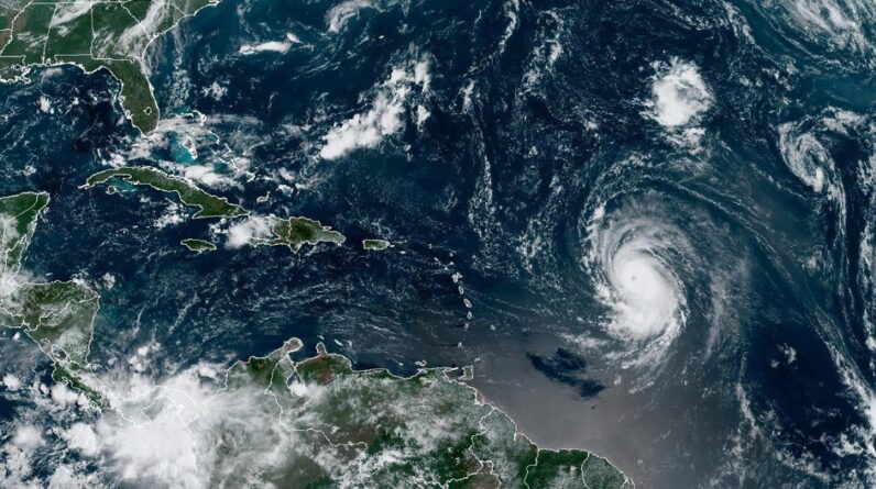
GOES-East – Continental U.S. (CONUS) Images
Hurricane Lee is a Category 4 storm.
\Source – NOAA/GOES EAST
Hurricane Lee has rapidly strengthened into a very dangerous Category 4 storm with sustained winds of 130 mph (215 kph).
As of the 5 p.m. advisory from the National Hurricane Center (NHC) Hurricane Lee was about 780 miles (1,260 kilometers) east of the Leeward Islands, which are in the northeastern Caribbean, and it was moving west-northwest at 15 miles per hour (24 kph).
The hurricane will continue moving in this direction for the next several days while
gradually slowing down its forward speed. On the forecast track, the core of Lee will move north of the northern Leeward Islands during the next several days.
Dangerous surf conditions generated by the storm are likely to affect the Virgin Islands, Puerto Rico, Hispaniola, the Bahamas, and Bermuda over the weekend, according to the Hurricane Center, reports the New York Times.
Rip currents and dangerous surf will spread across the northern Caribbean on Friday and begin affecting the United States on Sunday, the center said.
Tracking Hurricane Lee
At this point in time, Lee will be experiencing even more rapid intensification because the forecast track takes Lee across some of the warmest waters in the Atlantic Ocean and through relatively calm upper-level winds – ripe conditions for a hurricane to grow more fierce.
Lee’s winds are expected to peak at 160 mph, or Category 5-strength, Friday night as it approaches the eastern Caribbean and is still expected to be a dangerous hurricane over the southwestern Atlantic early next week.
The hurricane center said “Fluctuations in intensity are expected after that, but Lee is forecast to remain a powerful major hurricane well into next week.”
 Hurricane Lee Tracking models, as of Sept. 7, 2-23. Source – Global Tropical Cyclone and Disturbance Information
Long-range forecasts suggest Lee will likely curve north next week before reaching Florida. Potential impacts from Lee along the rest of the U.S. East Coast remain uncertain.
Right now, all major hurricane models that meteorologists use to forecast storms indicate that Lee will curve away from Florida. Looking even further ahead, the latest forecasts suggest Lee’s path could vary across a wide swath spanning from the U.S. East Coast northward to eastern Canada, or skirt away from the coast entirely.
[ad_2]
Source link


