[ad_1]
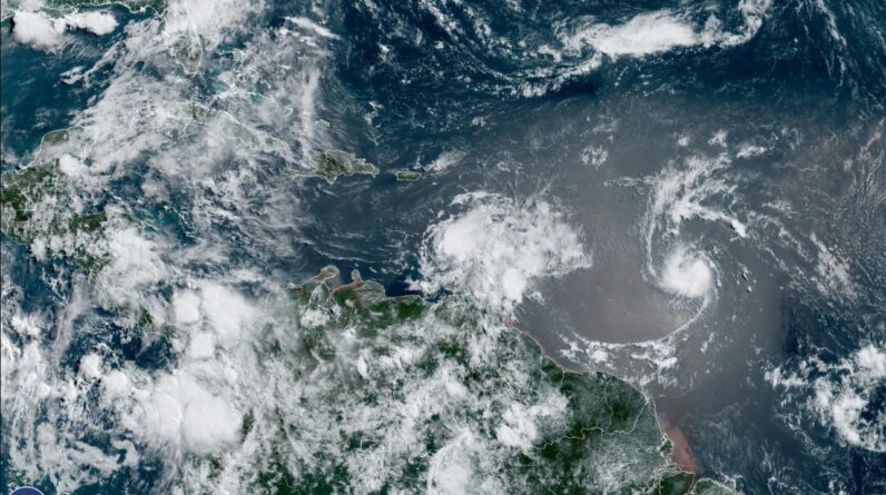
This GOES East sector view shows the outline of Floeida in the upper left of the image. T.S. Brett is at the lower left and T.S. Cindy is close to the center of the image.
Source – NOAA, GOES 16.
For the first time since record-keeping began, we are seeing two storms in the tropical Atlantic in June.
The National Hurricane Center is tracking two tropical storms today, although neither storm is expected to become a hurricane, and neither is a threat to the United States.
The historic event signals an early and aggressive start to the Atlantic hurricane season that began June 1, according to the Associated Press. Forecasters have blamed unusually high sea temperatures for the rare development.

TROPICAL STORM BRET
Tropical Storm Brett began moving away from the windward islands and moving into the Caribbean Sea on Friday. Bret brought winds, heavy rain, and swells of up to 15 feet (4.5 meters) early Friday to islands in the eastern Caribbean
Officials in the French Caribbean island of Martinique said they were searching for four people who were aboard a lifeboat after their catamaran sank during the storm.
At 8:00 am EDT, Brett was west of St. Vincent and moving to the west into open waters at 18 mph (30 kph). Its maximum sustained winds were 60 mph (95 kph). It peaked just under hurricane intensity on Thursday with 70 mph winds.
A tropical storm warning continued for St. Vincent and the Grenadines, but the warnings had been dropped for the rest of the Windward Islands on Friday morning.
Wind shear is forecast to increase in the Gulf of Mexico, and Bret is expected to weaken and dissipate in the Caribbean over the weekend, according to the hurricane center.

TROPICAL STORM CINDY
The newest tropical system in the Atlantic is Tropical Storm Cindy. As of 4 a.m. CDT Friday, Tropical Storm Cindy was located about 990 miles east of the Lesser Antilles and was on a path to the west-northwest at 15 mph.
Cindy’s maximum sustained winds were around 45 mph (75 kph) early Friday, and forecasts called for some strengthening.
The hurricane center said that if Cindy stays on the forecast track it should remain well east and northeast of the northern Leeward Islands through early next week.
Right now, the long-range track for Cindy shows it weakening to a depression and then a non-tropical system by Wednesday, when it could be somewhere between the Bahamas and Bermuda.
[ad_2]
Source link


